
Healthcare RTLS Solutions
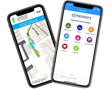
Hospital Wayfinding
Leverage the unparalleled precision, reliability and connectivity of real-time location services (RTLS) to create a GPS-like, turn-by-turn guidance solution for healthcare facilities.


Healthcare RTLS Solutions
Transform Hospital Navigation With Bluetooth® Low Energy-Powered RTLS
Save Staff Time
Stop redirecting lost patients. Real-time navigation enables everyone to reach their destination without requiring staff intervention.
Reduce Missed Appointments
Direct patients from home to their appointment with precise indoor navigation. Fewer no-shows result in better resource utilization and increased revenue.
Boost Patient Satisfaction & Revenue
Navigation frustration drives negative reviews. Intuitive wayfinding enhances the patient experience, leading to increased return visits and referrals.
Better Outcomes Through Reduced Stress
Complex hospital layouts create anxiety that impacts health outcomes. Our system creates a calmer environment, especially for elderly patients and those with disabilities.
Healthcare RTLS Solutions
HID’s Enterprise Wayfinding System
Precision Navigation
Precise positioning and real-time updates ensure users can navigate complex environments with confidence.
Multi-Channel Platform
Our solution is available for mobile, web and kiosk, ensuring that all patients and visitors can access Wayfinding.
Healthcare Focused
Our solution is offered exclusively to the healthcare market. Our expertise and focus are centered on the specific use cases and challenges that are unique to hospitals and healthcare environments.
Integration & Scalability
Our enterprise solution offers a standalone app or SDK for integration into existing systems and supports EMR and appointment reminder integrations to enhance user engagement and experience.
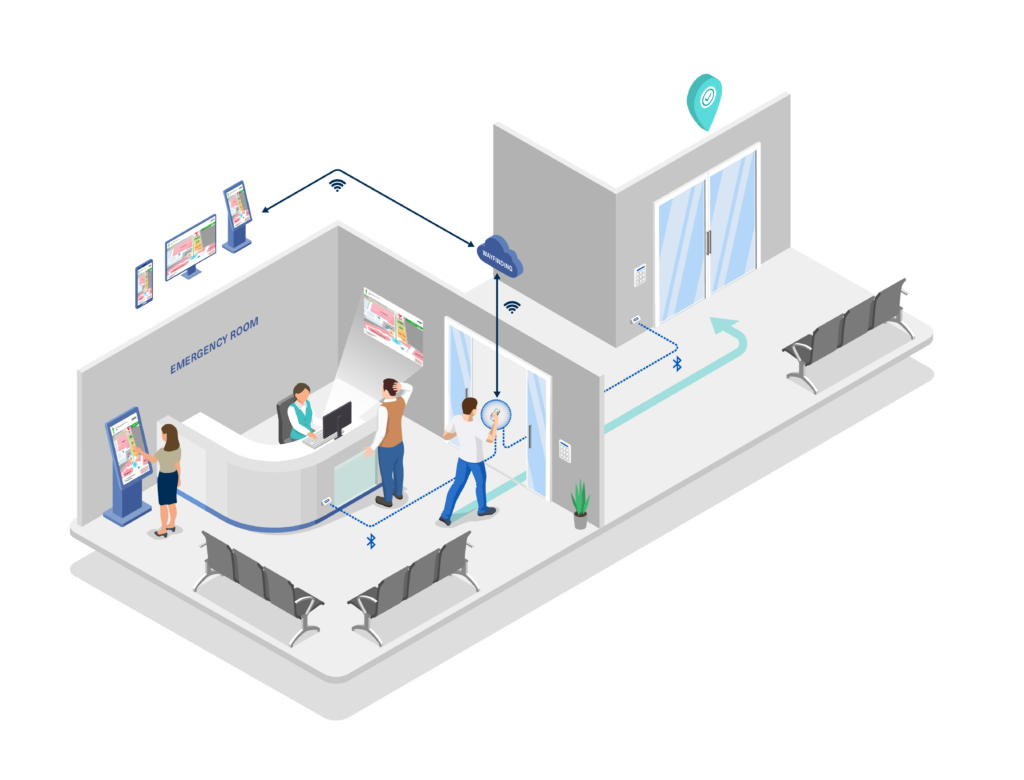
Bluetooth® Low Energy & Mobile Device Technology
Our Wayfinding Solution utilizes Bluetooth® Low Energy-enabled infrastructure located throughout a building or campus.
The solution also uses various sensors on the user’s device, like a compass, an accelerometer and a GPS for positioning from home to campus. This powers the precise, real-time positioning in our user-friendly, turn-by-turn map that guides users from their current location —whether that be their home, another facility or the parking garage — to their destination with ease.
HID has multiple Bluetooth® Low Energy-enabled infrastructure offerings which may power the Wayfinding Solution as well as our other healthcare RTLS offerings. These devices come with a battery, AC or DC power. Depending on your specific needs for now and in the future, HID can develop an infrastructure plan with you to ensure maximum utilization of your infrastructure investment. The solution is also compatible with most Bluetooth® Low Energy-enabled WiFi infrastructure.

Healthcare RTLS Solutions
Digital Wayfinding System Key Features
Our Wayfinding Solution is specifically focused on healthcare and the unique challenges and use cases
found along a patient’s or visitor’s journey getting to and from their appointments.
Parking
The Parking Planner feature recommends the closest parking garage, lot or valet to an appointed location. MyCarSaver directs users back to their car when they are ready to leave the hospital.
Effortless Map Management
Keep your facility maps accurate and up to date with our self-serve online CMS portal — no technical expertise required. Hospital admins can easily edit, publish and manage navigation updates in real time.
Location Sharing
“Meet Me” lets users share current (or future) locations with loved ones so they can meet at an appointment or pick-up spot.
Location-Based Alerts
Generate alerts for pharmacy pickups, blood drives or café locations. Provide directions to staff areas and construction zones with important location information.
Customization
Since all facilities are unique, so is every deployment of the Wayfinding Solution. Our feature customizations are nearly endless, and every application is designed using the hospital’s logo and brand colors.
Analytics
Our analytics platform provides metrics and insights about how users are engaging with the solution and what routes and locations are being navigated to.
HEALTHCARE RTLS SOLUTIONS
Hospital Wayfinding FAQs
Bluetooth®-enabled navigation helps visitors, patients, and staff reach their destination without getting lost, no matter how complex the facility.
How does Bluetooth® Low Energy-based positioning differ from traditional GPS in indoor environments?
The accuracy of our Bluetooth® Low Energy-based positioning system is much more precise compared to GPS and can locate the user’s position on various floor levels and seamlessly transition between them.
Can the solution be used in multi-story buildings for vertical positioning?
Yes, our solution can provide vertical positioning information in multi-story buildings. By utilizing multiple access points strategically placed on different floors, the solution can accurately determine the user’s position along both horizontal and vertical axes.
How can users access the solution?
The application is available as a desktop web application for pre-planning and can be accessed via its own URL or embedded into another website. Our mobile apps are available as stand-alone branded apps on the App Store and the Play Store or as SDKs that can be embedded within another application. The kiosk version is also a web app that can be accessed via a URL (pre-loaded onto a kiosk hardware station in the facility).
Can the solution route from off-campus to an appointment inside the hospital?
Yes, our solution is end-to-end, meaning it can detect a user’s current location off-campus, navigate them to the appropriate parking location, and then navigate them across campus, inside and to their appointment location. While utilizing multiple technologies, including GPS and Bluetooth® Low Energy to power the solution, the end user will experience a seamless transition along their journey from driving or taking public transportation to walking inside the facility.
What other RTLS solutions can be enabled through the same infrastructure as wayfinding?
HID’s suite of RTLS offerings includes infant security, staff safety, wander management and asset management. Please get in touch with your HID rep for info on how wayfinding can be enabled with other existing HID RTLS solutions.
Trusted by Industry Leaders
Recognized by Analysts
HID’s Healthcare RTLS solutions meet the highest standards for safety, interoperability, and innovation. Our team of RTLS experts are committed to delivering technology that healthcare providers can trust, through rigorous quality control and seamless system integration.
Named in Gartner research for excellence in real-time location services, highlighting our proven track record in healthcare asset and patient safety solutions.
Rated highly by customers for delivering real value in clinical workflows and security, backed by responsive service and dependable performance.

Recognized for sustained growth, innovation, and leadership in the RTLS technology space.
HEALTHCARE RTLS SOLUTIONS
HID Healthcare RTLS Suite
HID offers a wide-ranging Healthcare RTLS Suite of solutions.
We offer scalable, robust location services, including:

InVIEW Asset Management
Real-time location of your healthcare equipment.

TotGuard Infant Security
The most accurate and expandable solution on the market.

Wander Management
Safeguard vulnerable patients without restraining movement.

Staff Safety
Call for help with a discreet and wearable alert button.
Hospital Wayfinding
GPS-like, turn-by-turn guidance solution for healthcare facilities.

Environmental Monitoring
Real-time monitoring for temperature, humidity, & air quality in healthcare facilities.


Hand Hygiene
Hand hygiene monitoring system built to combat healthcare-acquired infections.
Next Step:
Talk to our Healthcare RTLS Experts
Find out how much your organization can save - and how quickly you can start seeing ROI - with a professional healthcare RTLS assessment. Our experts will review your needs, identify opportunities, and provide a clear roadmap for improving asset visibility and control.